Métis Trails of Western Canada
par Kermoal, Nathalie
On the 17th of February 1997, a plaque was unveiled atthe Alberta Legislature in Edmonton. Simultaneously, the same event was being commemorated at the Fort Garry Hotel in Winnipeg. Members of the Métis Nationof Alberta and Manitoba as well as representatives of the Ministry of CanadianHeritage and local historic associations came together on that day ofcelebration. No monument was inaugurated and no tribute was paid to any personin particular. Instead, these representatives were gathered to underline thenational historical importance of the Carlton Trail, a transportation routethat marked the development of the Northwest during the 19th century.
Article disponible en français : Pistes métisses de l'Ouest canadien
Essential Trade Routes
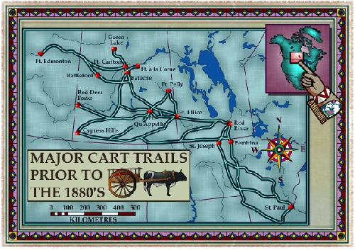
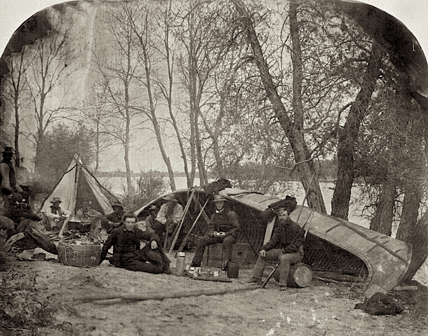
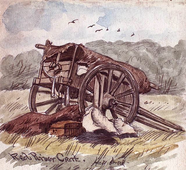
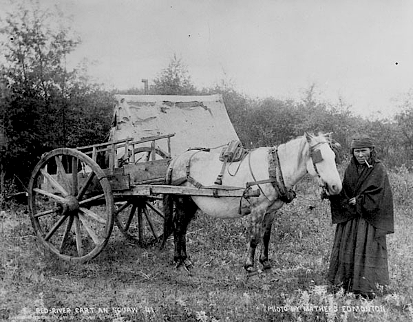
Thi sroute, or trail, which was 1,400 km long, stretched from Fort Garry (now Winnipeg) to Fort Edmonton. It followed approximately the same path as the present-day Yellowhead highway. For centuries, Native hunters travelled regularly along this path leaving behind them a scattering of artefacts that archaeologists in the 20th century would later come to discover. In the middle of the 19th century, the number of Métis freighters travelling the route increased. These people filled many roles as interpreters, guides, messengers, transporters, traders and suppliers, thus quickly becoming essential partners in the fur trade, as well as in the conveyance of merchandise. Trails and rivers were their routes of communication, and the Red River Cart was their preferred means of transportation.
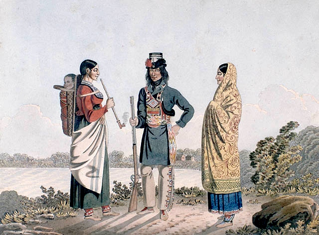
In addition to bison hunting, their economic activities centred around the fur trade and the transportation of merchandise. This made these men and women essential partners in developing the West and even Canada itself. Métis workers were in high demand because of their abilities and endurance. Today, despite the fact that it is difficult to retrace certain trails (the trails have grown over), the Métis have left their mark on the territory. They not only built trails across the land, but they also constructed temporary and permanent villages close to streams, rivers and wooded areas. These were easily recognisable, because of the long elongated shape of their farm lots. Some of their villages were Saint-Boniface, Saint-François-Xavier, Saint-Laurent, Batoche, Willow Bunch, Edmonton, Saint-Albert, Lac Sainte-Anne, etc. Often, new immigrants were integrated into these Métis communities.
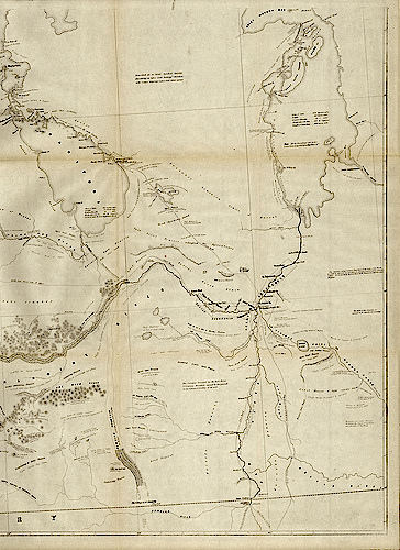
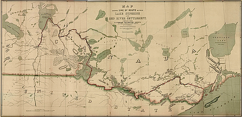
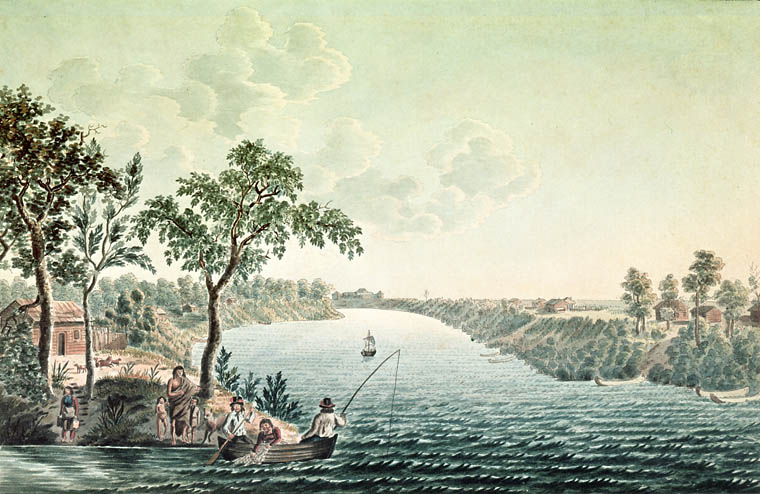
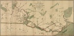
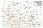
19th century maps indicate the presence of Métis settlements and also reveal their commercial activities. For example, S.J. Dawson's 1859 map shows the scope and complexity of the trails of the time. The map was created using information gathered from the Métis. It accompanied Dawson's report on the Red River Expedition, which was mandated by the Government of Canada in 1857-58 in anticipation of eventual large-scale colonisation in the West (NOTE 1). Because they were participatingin activities that were essential to the proper functioning of the fur trade (such as trapping, fishing, commercial hunting, making pemmican, transporting freight), the Métis had a crucial role to play in maintaining the mercantile economy throughout the 19th century. In fact, they worked for both the Hudson's Bay Company and the Northwest Company until the merger of the two in 1821. They were able to do so freely, as they did not have any attachments to either company. The land and river transportation system was at the heart ofthe lives of the Métis people, many of whom led a very nomadic existence.
The Carlton Trail
The Carlton Trail, "after crossing Southern Saskatchewan close to the future settlement of Batoche, crossed Northern Saskachewan and was developed in open Park Land, on the left bank of the river providing shelter from the possible conflicts with the tribes of the plains which threatened more southerly routes."(NOTE 2). Given its length, the trail crossed geographically diverse regions and was hence known by names, which differed in accordance with one's location on the trail. In Minnedosa, the trail was called little Saskatchewan or Minnedosa trail. In Shoal Lake (where the Northwest Mounted Police had a post), it was called the Fort Ellice (Saint-Lazare) trail (NOTE 3). West of Fort Ellice, people spoke of the Qu'Appelle Trail. Travellers that headed east on the route called it the Fort Garry Trail. In Saskatchewan and Alberta, people called it the Saskatchewan, Carlton, Battleford, or the Edmonton Trail (NOTE 4).
It required two months of travel to get from Fort Garry to Fort Edmonton by horse-drawn cart. At Fort Edmonton, a trail went towards the north to join the waterways of the Athabasca and Mackenzie Rivers. A trail also headed west from Fort Edmonton towards Jasper, passing through Saint-Albert and Lac Sainte-Anne. Another headed towards the south passing through Tail Creek (close to Red Deer), Fort MCleod, reaching all the way to Montana (in the Milk River region). From Carlton House, the trail headed towards Green Lake. Merchandise and furs were transported towards Île-à-la-Crosse and then towards La Loche or Methye Portage. Later, fleets of boats owned by the Hudson's Bay Company headed towards Athabasca. In the 1870s, the celebrated Métis leader Gabriel Dumont was reported to have worked on the upkeep of the Green Lake Trail, contributing to the construction of bridges over rivers and ravines and helping to clear the way for a twelve-foot wide route (NOTE 5). The Green Lake Métis were involved in the fur trade until its eventual demise when they became traders, labourers and freighters (NOTE 6).
In the 1890s, the Carlton Trail stopped being used for transportation, as parts of the Canadian Pacific railway began to extend further north. The train gradually replaced carts as a means of transportation.
Other Trails
In addition to the Carlton Trail, many other trails were developed with in Canada and also between Canada and the United States. These trails crossed the whole Northwest, through prairies and wooded areas (including the Boreal Forest) and also crossed a transitional area called the Parkland. Different routes were developed as trading posts were created in Canada and the United States. American garrisons "[also] had the habit of asking the Red River for supplies of beef or wheat necessary to their survival" (NOTE 7). The Métis transported merchandise to Pembina or Saint-Paul, Minnesota and carried back American products produced at a better price allowing them to bypass inspection by the Hudson's Bay Company.
The Métis would leave Fort Garry and head along the Red River passing through Saint-Agathe (Manitoba). From Pembina, there were three possible routes: two passed over the plains and one through the woods. The first two followed either the west bank or the east bank of the river. The first went as far as Fort Snelling and the other Saint-Cloud. The third trail started south of Wild Rice River and continued south towards Saint-Cloud and finally to Saint-Paul (The Métis followed along the east bank of the Mississippi River). This trail was known by many names such as the Saint Paul (or Pembina) Trail or the Crow Wing Trail.
The origins of the trails are relatively unknown, however, traffic between Fort Garry and Saint-Paul was substantial in 1849 and remained so throughout the 1850s and 60s. It seemed that the Saint-Paul Trail was created to avoid possible attacks by the Sioux people. After 1870, in addition to dealing with depleting bison herds, the Métis also lost access to the bison fur trade between Red River and Saint-Paul, because of increased tariffs and numerous customs control points between Canada and the United States. The American army frequently patrolled the border. Subsequently, north - south trading, notably between Pembina and Saint-Joseph was no longer profitable. Furthermore, because contraband was too risky, the Métis were forced to take their activities to Western Canada and to the states further west (especially Montana) allowing them to follow the bison herds.
Along the Assiniboine River, the Métis took the Pelley Trail (constructed in 1829), which led to Fort Pelley. This trading post was built at a strategic point and received furs sent from York Factory (NOTE 8), which was established on the western shore of the Hudson Bay. Other routes existed across the Northwest allowing easier transportation of supplies to Métis trading posts and missions.
Catholic Missions in Western Canada depended heavily on Métis labourers to transport merchandise. In theory, because they were isolated from each other, they had tobe self-sufficient. In practice, the scarcity of merchandise and the difficulty and high cost of transportation meant that they were at the mercy of the Hudson's Bay Company, which was not always willing to transport products at a lower cost. As a consequence, the Oblates built warehouses to store products they needed. From 1869 to 1889, Notre-Dame-des-Victoires, at Lac La Biche (located between the basins of the Mackenzie and Churchill Rivers), served as a warehouse for merchandise destined for missions in the North. In order to ensure the transportation of building materials and perishables, a road was built between the Mission and the Athabasca River. This avoided a problem presented by certain rivers in the region, which had water levels too low for travel (NOTE 9).
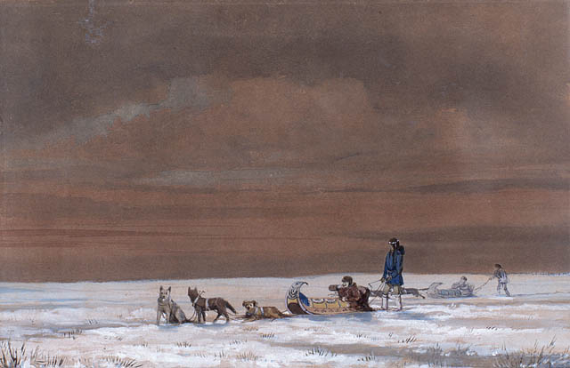
The Métis travelled in caravans or in a line of wagons that would criss-cross the country. The Red River carts were particularly well adapted to travel on the Prairies. Nevertheless, travel was impossible if the terrain was too rugged. Numerous carts had to stop at rivers or lakes to load or unload merchandise or bundles of furs. Fleets of boats, also operated by the Métis, which travelled to and from the Athabasca and the Mackenzie rivers, were thus provided with fresh supplies.
Over time, the main corridors used by the Métis to transport merchandise and services, which linked the North and the West to the rest of Canada and the United States were replaced. They gave way to steamships, the railway, and eventually roads and trucks.
Trails of Memories
The Métis did not only criss-cross the land with these routes, in order to transport merchandise or just to get closer to bison herds. The Exodus continually pushed them further west. After the events of 1870 in Red River, which established the temporary government led by Louis Riel, the Métis were more marginalised than ever before. As a consequence, the question of Métis land ownership went unresolved and certain families decided to leave Manitoba and to take their chances elsewhere. Most of those families followed the Carlton Trail.
In addition to the Métis, numerous well-known travellers made use of these trails; it ws a sign of the times, as Canada was undergoing great expansion. These individuals include Robert Rundle, first Wesleyan missionary to the Stoney Nation in Alberta, the explorers John Palliser and Henry Youle Hind at the end of the 1850s, as well as other missionaries such as Father Albert Lacombe. Many other people also followed these land trails including: emigrants settlers, travellers, sport hunters, missionaries, adventurers, and dignitaries. In addition, the Northwest Mounted Police and the Northwest Field Force used these overland trails during the Native and the Métis events of 1885 (NOTE 10).
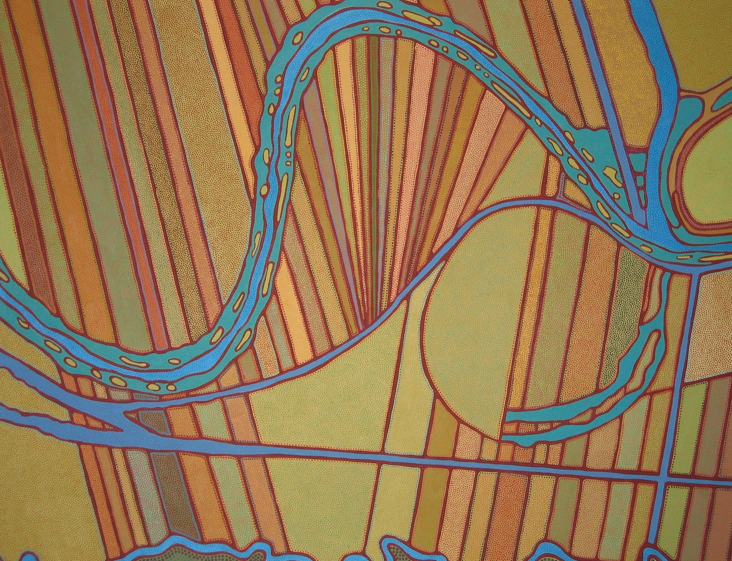
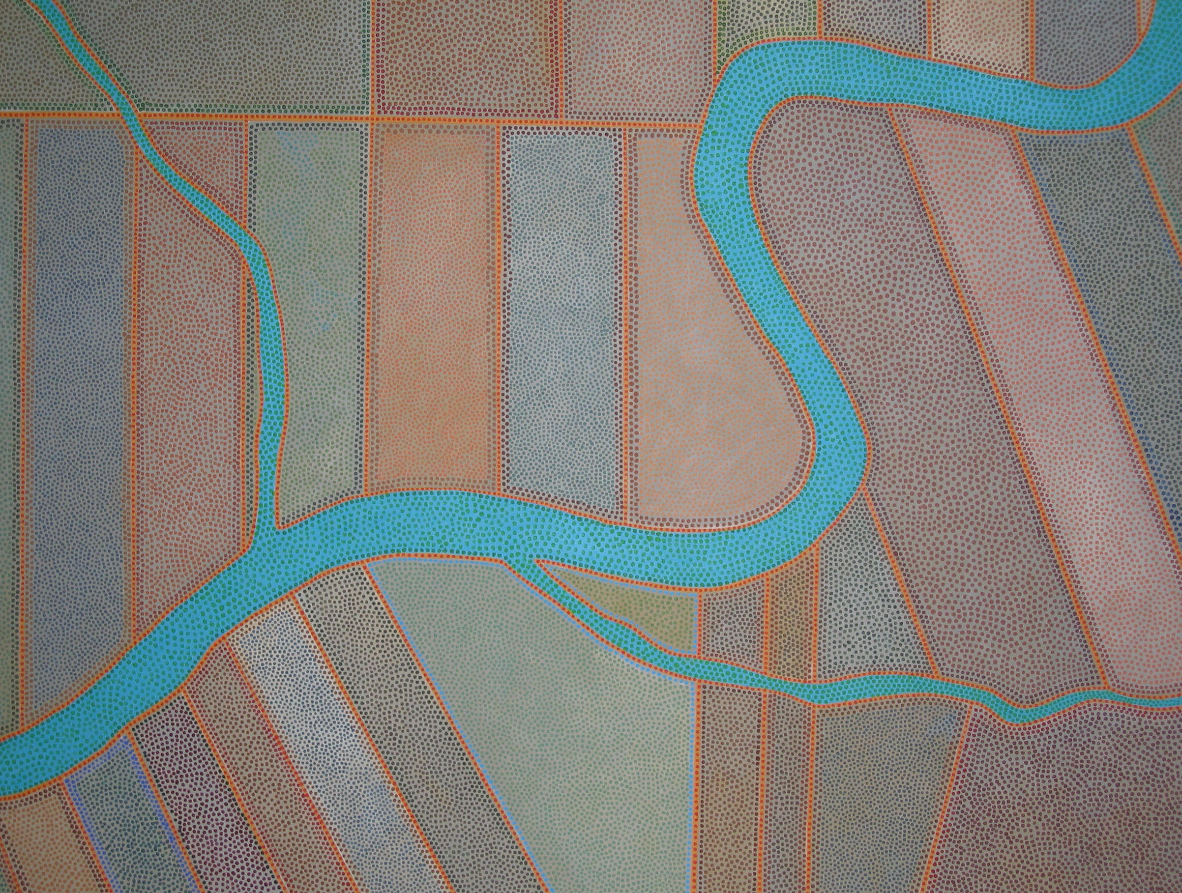
Since the days of the fur trade, things have certainly changed. However, the Carlton Trail is still present in collective memory of the Métis. David Garneau, great great grandson of Laurent Garneau, a well-known Métis businessman, after whom an Edmonton neighbourhood is named, presented an exposition in 2008 entitled "Along the Carlton Trail". It was inspired by the travels made by his ancestorand the other Métis for business or by obligation because of the Exodus. The artist tells the story using a technique described as "beading", which recalls the beadwork done by Métis women (NOTE 11). He follows their steps on the route in the 1870s, from Red River, passing through Sainte-Madelaine (today non-existent), all the way to Edmonton in the 1880s. By drawing inspiration from 19th century cartography, Garneau clearly depicts the abundance of rivers in the region, in order to emphasize the Métis influence on the history of these towns and villages. He regularly travels the Yellowhead Trail by car taking photographs of the animals killed onthe road. The strange shapes of "road kill" transformed into artwork stress the effects of settlement on nature. He says, "I travel this route as if it were a hunting trail! I trap animals, I make pelts and I try to sell them" (NOTE 12). In 2004, the Métis organised an expedition with a bit of a heritage twist to it. They called it the "Red River Métis Heritage Journey". During this trip they used Red River carts and followed the old Métis routes.
The Métis trails were unavoidable for centuries because, aside from rivers, there were no other routes that could be travelled. However, in time, the land changed, giving place to a new colonial reality that depended on agricultural development, railways, and immigration. After 1885, the Métis became more and more dispersed. Even if the old trails never fully disappeared from official maps, at the beginning of the 20th century they remained marginal, just like the people that used to travel them. Today, the few sections of trails that remain attest to the central role the Métis played in developing the country. They are also clues that tell the story of an ever mobile, migrant people that, because of its transportation and hunting activities, ensured the survival of many settlers. Their heritage deserves to be better known.
Nathalie Kermoal
Associate professor
Faculty of Native studies and of the Campus St. Jean of the University of Alberta
NOTES
Note 1. Étienne Rivard, "Territorialité métisse et cartographie du Nord-Ouest canadien au XIXesiècle : Exploration cartographique et toponymique", CEFCO, volume 14, no 1 et 2, 2002, p. 15.
Note 2. Marcel Giraud, Le Métis canadien, Paris, Institut d'ethnologie, 1945, p. 981.
Note 3. It is also called the Touchwood Pathway (because it goes through the Touchwood hills).
Note 4. Frank Hall, "Carlton Trail : First Western Highway", Manitoba Pageant (printemps 1969), volume 14, no 3, p. 2 et 3.
Note 5. Tough, Frank et Alison Magill, The History and Development of the Green Lake - Carlton Trail, Saskatoon, Infinity Research, Development & Design Inc., 2003, p. 6.
Note 6. The North-West Company constructed a fort there in 1782.
Note 7. Giraud, p. 975.
Note 8. Harry Baker Brehaut, "The Red River Cart and Trails : The Fur Trade", Manitob aHistorical Society Transactions Series 3, no 28, 1971-72, p.12-13.
Note 9. Huel, p. 60-61.
Note 10. Hall, p. 2.
Note 11. Garneau speaks also of the influence of the pointillism technique of Seurat as well as the influence ofthe painting of Australian Aboriginals.
Note 12. David Garneau, "Along theCarlton Trail", Artist Statement, 2008, p. 3.
BIBLIOGRAPHY
Baker Brehaut, Harry, "The Red River Cart and Trails : The Fur Trade", Manitoba Historical Society Transactions Series 3, no28, 1971-72, p. 1-21.
Fonseca, William, "On the St. Paul Trail in the Sixties", Manitoba Historical Society Transactions Series 1, no 56, 1900, p. 1-7.
Garneau, David, "Along the CarltonTrail", Artist Statement, Exhibition at the Godfrey Dear Art Gallery, September 25-October 31, 2008, p. 3.
Giraud, Marcel, Le Métis canadien, Paris, Institut d'ethnologie, 1945, 1316 p.
Hall, Frank, "CarltonTrail : First Western Highway", Manitoba Pageant (printemps 1969), volume 14, no 3, p. 1-3.
Huel, Raymond, Proclaiming the Gospel to the Indians and the Métis, Edmonton, University of Alberta Press, 1996, 387 p.
Rivard, Étienne, "Territorialité métisse et cartographie du Nord-Ouest canadien au XIXe siècle : Exploration cartographique et toponymique", CEFCO, Volume 14, no 1 et 2, 2002, p. 7-32.
Tough, Frank et Alison Magill, The History and Development of the Green Lake - Carlton Trail, Saskatoon, Infinity Research, Development & Design Inc., 2003, 41 p.
Additional DocumentsSome documents require an additional plugin to be consulted
Images
-
 Carte montrant la rou
te reliant le l... -
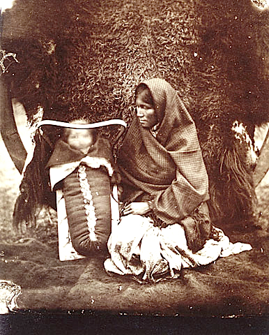
 Femme ojibwée et un e
nfant dans un p... -
 Méandres dans la rivi
ère Rouge près ... -
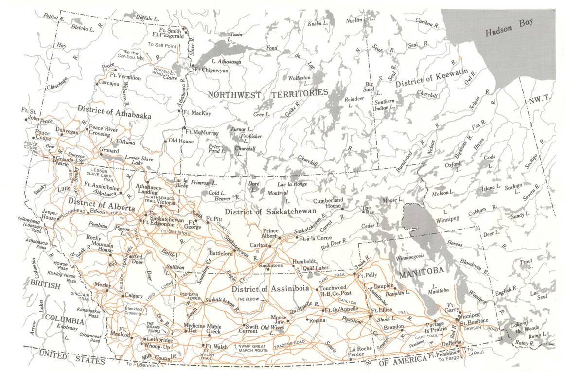
 Sentiers tiré de Atla
s of Alberta Ra...