Acadian Aboiteaux [Dike and Suice Gate System]
par LeBlanc, Ronnie-Gilles
The word aboiteau [dike and sluice system] has become a central part of the identity of the Acadian people, the maritime technology being so closely linked with the rise and evolution of this group of people during the 17thand 18th centuries. Even after the Deportation of the Acadian people in the 1750s, this farming practice was preserved in some of the Acadian regions.The aboiteau-style dike and sluice has now become a symbolic part of the cultural heritage of the Acadian community, which still perpetuates the memory of the maritime technology's historic importance. Throughout the colonial period, Acadians were the only people in North America to cultivate below sea level farmlands to such a large extent. These exceptionally fertile lands were the key to the community's prosperity up until the even of the Deportation in 1755. Moreover, these large-scale earthworks were community projects. This sets them apart from similar projects undertaken elsewhere in the world. The communal tasks necessary to building and maintaining the large network of dikes have helped forge the Acadian identity into what it is today.
Article disponible en français : Aboiteaux acadiens
Preserving and Promoting the Aboiteaux Today
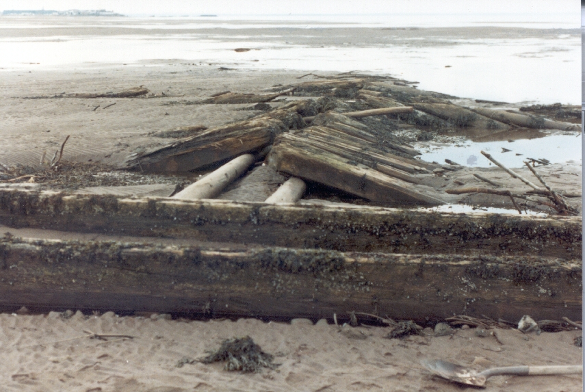
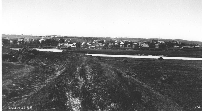
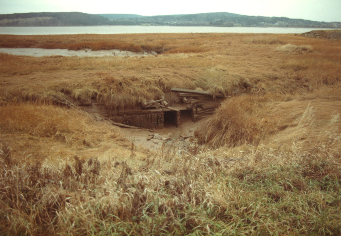
During the last three decades, about half a dozen aboiteau-style dikes and sluices have been reclaimed from some of Nova Scotia and New Brunswick's marshes and preserved for future exhibitions exhibits. Among them are the sluices presently on exhibit at l'Église Historique de Barachois, in New Brunswick. In Nova Scotia, there are also those on display at the Musée Acadien de Pubnico and at the Grand-Pré National Historic Site of Canada. There, the aboiteau-style dikes historical and cultural importance is explained to visitors. Furthermore, in 1997, the construction of the network of dikes was declared to be an event of national historic importance by the Historic Sites and Monuments Board of Canada. In Grand Pré, one of the two sluices on display was built in the late 1680s, which is when the work to drain the marsh is thought to have just begun. Another set of sluices comes from the former Acadian village known today as the Melanson Settlement National Historic Site of Canada. The Board will also erect a plaque in the Memramcook region to commemorate the dike building as an event of national importance.
Many other Acadian museums, such as the Musée Acadien de l'Université de Moncton, offer information on the aboiteau-style dike and sluice systems or display various elements from the dike and sluice mechanism. These institutions also offer virtual exhibits or virtual replicas of aboiteau-style dikes and sluices on their websites. In the Village Historique Acadien, near Caraquet in New Brunswick, levees and aboiteaux have been built in the local marshlands.This goes to show just what an important part of the Acadian cultural heritage the aboiteaux are.
The Natural Surroundings
The aboiteaux-style dike and sluice system for controlling water levels in the sub sea-level areas of the Maritimes was developed in a very unique environment, the alluvial lands being shaped by the turbulent waters of the Bayof Fundy (or Baie Française [French Bay], the bay's earliest official name). There, the tides are among the strongest ones in the world, rising to heights of up to 15 metres [50 feet]. The marshes surrounding the Bay of Fundy are the result of the ebb and flow of the tides that have deposited sediments rich in organic matter and minerals. Once drained and desalinated, the lands are exceptionally fertile, so much so that no fertiliser needs to be added to the soil even after many decades of farming.
Before the arrival of the first Acadian settlers, the Bay of Fundy's low-lying, muddy, tidal flats (the wadden) flooded twice daily. The higher areas, the salt marshes (the schorre), were flooded only by the strongest tides. When the sea would recede, the mud flats and the salt marshes were scattered with muddy streams, alive with marine life. It was the Bay of Fundy's powerful tides that made the soil so rich. It promised the region considerable agricultural potential once the marshes were drained and the salt removed.
To make use of the rich soil, farmers first needed to deal with the daily movement of the strong tides (NOTE1). In fact, twice each day, 100 billion tons of seawater still rises and recedes from the bottom of the Bay of Fundy, which is more water than is contained in all rivers of the world combined. Along the Annapolis Basin, where the first aboiteaux-style dike and sluice systems were built by Acadian settlers, the tidal heights can vary from 4 to 8.5 meters [13 to 28 feet]. While in the Minas Basin, the average tidal range is 12 metres [40 feet] and it can rise as high as 15 or 16 metres [50 or 53 feet] during the highest tides (NOTE 2).
When building the dikes, the Acadian settlers were able to put the region's natural resources to good use. The main construction materials came from the marshes themselves. They used sod to build and cover the levees as well as their aboiteaux-style dikes and sluices. The thick, tangled roots of halophytic plants (i.e. those that grow in saline environments)of the salt marshes grow deep, which not only helps them survive the effects of salt water, but also helps them, hold fast against the push and pull of the tides (NOTE 3). Sod was used to cover the sides of the levees, especially the side facing the sea. No other types of plants would have survived in salt water. Thus, the levee would have been quickly eroded by the powerful tides of the Bay of Fundy (NOTE 4).
The Acadians also understood and were thus able to make good use of the hydrography (the natural watershed) of the marshes, which they drained to their advantage. They would place the aboiteaux, the levees and the drainage canals in harmony with the natural flow of the streams in the drainage basin created bythe marsh. In the Grand Pré marsh, at least three drainage basins were identified, one bringing the marsh's waters towards the Gaspereau River, another towards the Cornwallis River and a third directly to the Minas Basin. Thus, they had to tame at least three different zones of the marsh before being able to farm the entire area. Furthermore, draining these zones was an operation that took many steps, which spread over three generations of Acadians, from the 1680s up until 1755 (NOTE 5).
The Design and Mechanics
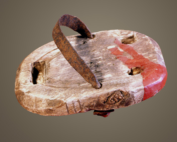
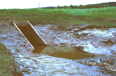
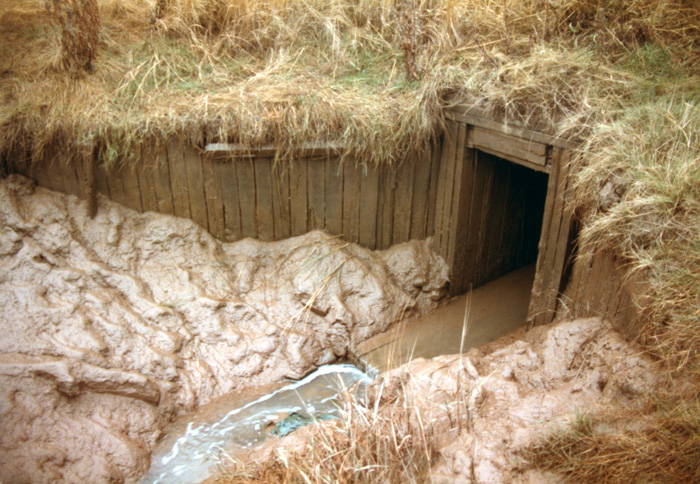
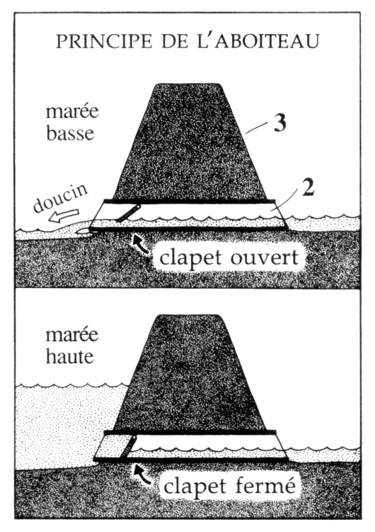
The French term aboiteau has two meanings; it refers not only the work associated with draining a marsh, but also to the drainage system itself, which is comprised of two parts: the sluice and the levee that protects it. The sluice is equipped with a gate that opens and closes automatically with the ebb and flow of the tide. Sluices were originally made of hollowed out tree trunks placed at the bottom of a drainage ditch. Levees were then built on top of the sluices, but unlike the rest of the system, the sluices were reinforced with tree trunks mixed with mud from the marsh. It was important for the aboiteau-style sluices to be carefully secured, in order to keep it from being dislodged by the force of the tides. The levees were built perpendicular to and wider than the drainage ditches, thereby keeping the seawater from flooding the marsh with each high tide. Under normal operating conditions, the pressure of the rising tide causes the gate to close, while the pressure of the run off accumulated in the marsh at low tide pushes it open. Thus, the constant motion of the tides causes the gate to open and close twice every twenty-four hours.
The first objective being to drain and desalinate the marsh, a network of drainage canals and ditches are dug all throughout the marsh. Because they would also serve as boundaries between parcels of land, these ditches were usually dug in straight lines. Deeper ditches were dug along the outer edge of the levee to protect the entire marsh. All linked together, the ditches drain into the canals that flow into the natural waterways that lead to the aboiteaux (sluice gates), which have been specifically placed where the natural stream flowed. Thus, rain water and fresh water running down from higher elevations, which would usually accumulate in the marsh during the high tide, is then able to trickle into the drainage canals and pass through the aboiteaux into the sea during the ebb (low) tide).Gradually, this surface run off washes away the salt present in the upper layers of the soil, making agriculture possible. The process takes two to three years for each parcel of land.
Tools used by Acadians to convert the intertidal areas into agricultural lands were quite basic: a kind of shovel known as a ferrées, pitchforks, axes, barrows and hollowed-out tree trunks. The success of the project mostly rests on the ingenuity and cleverness of Acadian settlers who were able to understand and take advantage of the natural watershed of the marshes.
The Aboiteaux during the French Regime in Acadia
The word aboiteau originates from the Saintongeais and Aunisien dialects, where it is written aboteau. Dièreville uses this terminology when writing about the Acadian aboiteau system of Port-Royal in 1699. The word designating the dam or dyke does not exactly correspond to the real aboiteau system since it is missing one of the key elements, the valve. The French used a similar type of sluice gate in other applications for controlling the ebb and flow of the tide, such as floating gates and culverts. In addition, there are references to the technology more than half a century before Acadians started draining their marshes in the 1630s.
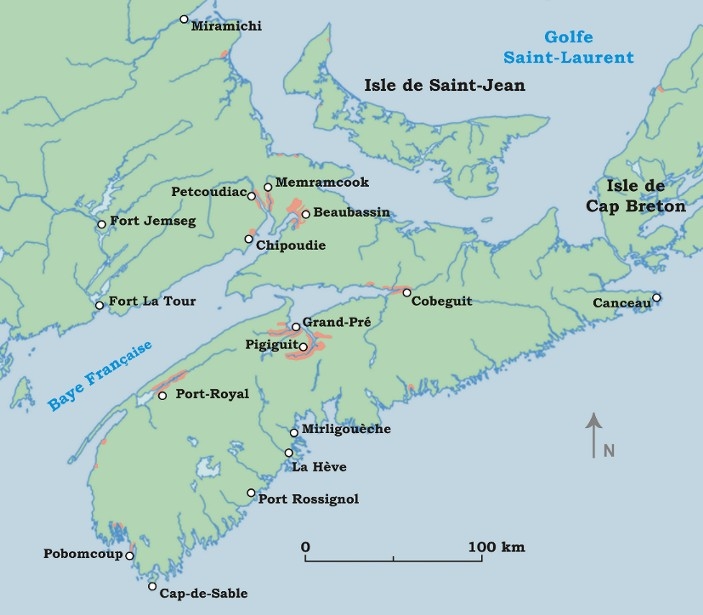
The tradesmen (who weren't exactly engineers) that were hired in France to go to the New World to drain the marshes of the Port-Royal River must certainly have known about the draining technique used with the aboiteau-style sluice and dike system, since they adapted it to the salty marshes of French Bay (e.g. the Bay of Fundy). In 1636, five saunier [artisans who extracted the salt from the sea water or from salt marshes], including a master saunier, were hired by the governor ofAcadia, Isaac de Razilly. Not long after their arrival in Acadia, Razilly died rather suddenly. It was Charles de Menou d'Aulnay who took command of the colony and who, seemingly, moved the settlement to the Port-Royal region (NOTE 6).The artisans all came from the La Rochelle region of France where there were salt marshes as well as Marais Poitevin, a former marsh that had already been drained. The French sauniers were probably the first to build levees and to dig drainage canals in order to drain the alluvial soils from the Port-Royal area (NOTE 7).
After being drained and desalinated the first parcels of land were planted and farmed. French settlers and their descendants, the Acadian people, were so impressed by how fertile and productive these lands were that they drained many other salt marshes of varying sizes along the French Bay (or Bay of Fundy) up until 1755. It is for this reason that the Acadians were nicknamed the défricheurs d'eau (clearers of water), because, contrary to most other North American settlers who cleared forests, they drained marshes. Of course, Acadians also cleared the woodlands along marshes' edge to build their villages, plant orchards and gardens and to raise livestock. But, the dominant method for creating arable land consisted of draining intertidal lands using the aboiteau system, which was an extremely rare technique in North America at the time. In fact, during the entire colonial period, Acadians were the only people in North America to farmlands below sea level on such a large scale.
The exceptional productivity of these lands was the reason behind the Acadian community's prosperity before 1755 and even more so in the Minas Basin, which is near Rivière-aux-Canards and Grand Pré. The area was once considered to be the granary of Acadia. Even though the drainage technique was used and tested in many different places, in Grand Pré, it was an entirely different matter, for no other part of Acadia had such high tides. Little by little, Grand Pré farmers converted almost all the area called La Grand' Pré into fertile agricultural lands. Only in the most western part of the marsh was not enclosed in dikes, when the Planters came from New England at the beginning of the Deportation (NOTE 8).
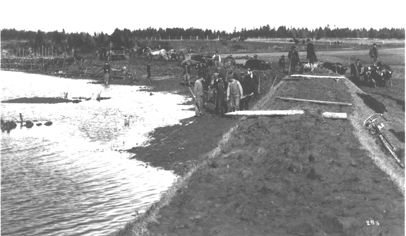
It is important to point that the aboiteaux built by the Acadians were community projects. This distinguishes them from similar projects undertaken elsewhere in the world that were commissioned by the ruling social class and carried out by serfs and tradesmen who had to work without pay or compensation. The transformation the large salt marsh in Grand Pré was however a consensus decision made by local farming families who lived in the area. And it was the very same individuals who actually built the aboiteaux over a period of three generations. Most of the other aboiteau construction projects followed the same process. It was only the initial project commissioned by Charles de Menou d'Aulnay in Port-Royal in the 1630s and Abbot Jean-Louis Le Loutre's unfinished project started in the Beaubassin area during the 1750s that were commissioned and overseen by a leader or someone higher in the social hierarchy.
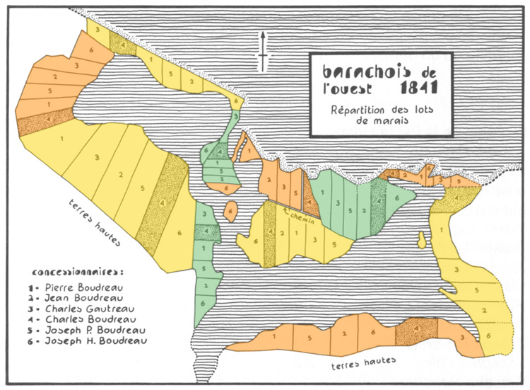
And so, the communal tasks related to the building of the aboiteaux, became central to the development and evolution of the Acadian cultural identity. It strengthened the ties between the people of an already close-knit community. Since every member of the community had worked onthe project, they all shared equal ownership of the drained marshlands. To divide the lots between themselves they used a lottery system, just as it had been done at Marais Poitevin. Having all participated on the project, each members of the community was considered an equal. Moreover, a community ownership of the marsh meant that each individual was responsible for the maintenance work related to the drainage system, such as dredging and cleaning the drainage canals as well as building and repairing the levees and the aboiteaux mechanisms. Thus, the owners of the marsh all relied on each other. This type of shared land ownership of the drained lots dominated Acadian culture and was later adopted by the New England Planters that settled there in the 1760s, when they took over the lands of the Acadians who had been deported in 1755 (NOTE 9).
Post 1755 Aboiteau Construction
Starting in the mid 1760s, Brithish authorities allowed Acadians to return to Acadia, from which many of them had been exiled. By then, the marshes that they and their ancestors had drained with the use of aboiteaux were now owned by Anglo-American or British settlers. Ironically, in 1760, Governor Charles Lawrence was obliged to put the Deportation on hold, for the hurricane of November 1759 had greatly damaged the aboiteaux and levees of the Acadian marshes and the governor had great need of the remaining Acadians and their knowledge of the aboiteau system. Hence, many Acadian families ended up in Port-Royal, Pigiguit and Beauséjour as prisoners of war. Many Acadians had to work on mending and building aboiteaux and levees for the benefit of the new owners of their former lands. By showing them how the aboiteau system worked, they forfeited to the invaders what was left of their former life from before the Deportation. It is one of the greatest tragedies of the Deportation because, not only did they lose their property, the Acadians were forced to reveal to their usurpers the secrets of a technology developed and perfected by their forefathers.
Only the marshes along the Memramcook and Petcoudiac rivers were not occupied by the conquerors. That is why it is the only region of Acadia where the aboiteaux are still functional today (NOTE 10). It was their descendants who passed on to present generation the knowledge oft his traditional Acadian technology. In other regions where Acadians are present today, notably in Pubnico and in Baie Sainte-Marie (Nova Scotia) as well as in the Cap-Pelé and Barachois regions and the Caraquet region of New Brunswick, aboiteaux were built and kept in working order up until the turn of the 20th century. It is also important to pointout that the technology was slightly modified to counter the effects of the storms that gradually eroded the turf-covered sand dunes that were used as levees.
The Aboiteau-style Dike and Sluice: a Piece of Acadian Cultural Heritage
The aboiteau system used by Acadians was ingenious. It is an adaptation of ancient technologies used in Europe. Today's aboiteaux use the same principles, buton a larger scale, especially in the former regions of Acadia that are now predominantly English-speaking communities. Considering their major role in the region and the people's history, it is no wonder that the memory of the aboiteaux is still very much alive in the minds of the Acadian people (NOTE 11).
Ronnie-Gilles LeBlanc
Historian
Parks Canada, Halifax
NOTES
Note 1. The Bay of Fundy's shape is largely responsible for the phenomenon because it acts as a kind of funnel for the incoming tides. The more the tide advances along the North-American coastline towards the back of the Bay of Fundy, the narrower it becomes, creating a impressively high tides.
Note 2. These maximum high tides occur during the equinox tides, in the spring and fall, as well as during the summer and winter solstice, the winter tides being the highest of the two because strong winter winds, which make the waters rise even more.
Note 3. The sod was composed of silt mixed with the roots of two species of grass: the salt hay grass, (Spartina Patens) and the salt marsh rush, (Juncus Gerardii).The two plants were key to the development of the aboiteau system, since they were used to reinforce the walls of the levees.
Note 4. The intertidal areas also provided Acadians with salt feed from the marsh grasses, which their livestock tended to prefer. The people of the region also harvested and ate two edible plants: the Sandfire Greens (Salicornia Europaea) and the Passe-Pierre, the last still being considered a treat by Acadians from the Memramcook Valley and from Pré-d'en-Haut, along the Petitcodiac River.
Note 5. The levees and aboiteaux built during the earliest drainage projects in the central part of the marsh succeeded in protecting the area from the tide when it breached the levee and badly damaged the aboiteaux during the hurricane of November 1759. It was this part of the marsh that was the first to be conceded to the Planters when they arrived in the Grand Pré region in 1760.
Note 7. For D'Aulnay, the project of draining the region's marsh remained a passion even until the very final days of his life. Just days before he died, he went to "[...] plant pickets, trace lines and run string lines to plot out the drainage of more land [...]" Taken from a letter written by Rev. Father Ignace,Senlis on August 6th, 1653, Collection de Manuscrits Contenant Lettres, Mémoires et autres Documents Historiques Relatifs à la Nouvelle-France, vol. I, Québec, Imprimerie A. Côté et Cie, 1883, p.138.
Note 8. Perrine Baudry, the widow of the master saunier, a man called Jean Cendre de Marennes, remarried in Quebec City in 1649. Was it possible that she and her late husband had lived in Acadia for many years after arriving in the New World? In that case, it could have been Jean Cendre who supervised the first drainage works during the 1630s and 1640s.
Note 9. The Planters nonetheless continued to develop and cultivate these lands after their arrival in the area in 1760. Farmers who now own the lands once farmed by the Acadian people and then later by the Anglo-American and British settlers up until the end of the 17th century still use the same farming practices today.
Note 10. Acadian families imprisoned at Fort Edward, in Pigiguit and at Fort Beauséjour were able to benefit from their proximity to these forts, because it was from there that they were given permission to settle on the remaining vacant lands around Memramcook and Petcoudiac.
Note 11. For the last few summers now, people have been celebrating the Festival de la Barge at the Amirault's Hill. The event commemorates an important aspect of the Acadian marshes: the haying time that once was an annual ritual closely related to the agricultural calendar established by the aboiteaux system in former Acadia.