Emblematic Landscapes of Lac-Tremblant-Nord: Natural Scenic Area and Cultural Heritage Asset
par Gourbilière, Claire and Joliet, Fabienne
Lac Tremblant is well-known due to its proximity to Mont Tremblant, which looms over it. The uniqueness of the site resides in the fact that, historically, the land use of Lac Tremblant has long been split into two subdivisions, which is reflected in the area's distinct landscapes. The southern part of the lake and the mountain have been turned into a world-renowned recreation area, whereas, since the beginning of the 20th century, the northern segment has been protected as a natural heritage scenic area, a fact which is evident in natural features of the region. In this way, the Municipality of Lac-Tremblant-Nord has preserved and carefully shaped the landscapes that now have become such a part of its distinct unique identity, a uniqueness that, for the local residents, is so much a part of what makes them proud to live there. From the earliest days, this natural scenic heritage, with all of its age-old evocative power, has been a protected area; long before such conservation measures were the norm. Today, however, it is now being threatened.
The Heritage Landscapes of Northern Lac Tremblant
Lac Tremblant is located at the foot of Mont Tremblant, which rises to an altitude of nearly 1,000 metres, making it one of the highest peaks in Eastern North America. The lake is 15 kilometres long and is one of the largest lakes in the area that for a long period of history was once known as Les Pays-d'en-Haut [The Upper Country]. There are over 4,000 such lakes in the Laurentian region alone, a fact that makes lakes obviously regular fixture in the Laurentian landscape, just as the peneplains are characteristic of the Canadian Shield.
The landscape of the lake's northern segment is a private heritage asset and is therefore closed to the public, although it can be seen and approached from on the lake, whose waters are accessible to the public. This area's access restriction has had much bearing on the preservation and management of the landscape's features, as well as on the kinds outside pressures that have succeded in encroaching upon the protected area.
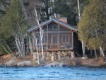
The Municipality of Lac-Tremblant-Nord covers a territory that includes the northern two-thirds of Lac Tremblant, as well as Lac Gervais and Lac Bibite located to the northwest. If one only examines Lac Tremblant's lakeshore and perimeter one discovers that the area is entirely without roads or permanent residents. The first summer cottages date back to the 1900-1905 period. By 1938, there were 33 and by 2007, 56 buildings on 84 lots. All are secondary residences used on weekends and during vacations.
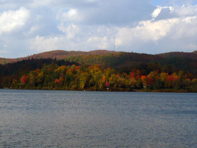
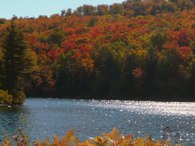
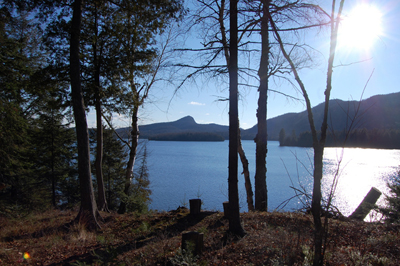
The landscape of the northern Lac Tremblant area is very homogenous. It consists of a vast enclosed lake nestled between mountainous ridges covered in the dense mixed forest (both hardwoods and conifers) that marks a transition zone that lies between the deciduous forests of the St. Lawrence valley and the boreal forests of the taiga. To the north, the lake is by the Cachée River, with the Cachées Falls as its southern outlet. The topography of the shoreline forms a curve that includes five main bays (Baies des Chevreuils [Stags] and des Ours [Bears] among others) as well as a centrally-located vista point that looks out over a stretch of water graced with seven islands (among them aux Cèdres [Cedars] and Cachée islands, etc.).
Out of the general homogenous landscape, it is possible to distinguish three natural motifs that are combined in a variety of ways to form the characteristic scenery that is the natural and cultural heritage of Lac-Tremblant-Nord.
The
natural wilderness motif:
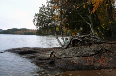
The wild or even "virginal" quality of certain areas of the landscape is
fundamental to its emblematic expression of being place of self-renewal or even
of spirituality. These are the raw
elements of the landscape that are so very unconsciously natural, yet so very
coveted as scenery which stages everything so artfully, particularly the
beaches, surface rocks, sinuous tree roots and geo-morphological features
(headlands, bays, islands, etc.) that reflect off the clearness of the water.
The
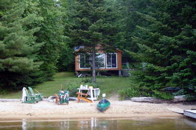
woodland cabin or lakeside cottage motif:
The imprint left by the surroundings is more artfully subtle and symbolic than
it is visible and ostentatious. The layout includes various buildings of modest
dimensions: the place of
residence, i.e. the cottage, normally a two-room building with an outhouse, an
outdoor chimney and a resting place for contemplation (even if a makeshift
one), to which the distinctly English cultural element of a sleeping cabin is
often added. This trace of human
occupation is more often than not concealed by a curtain of trees between the
structures and the lake, which just allows one to get a discreet glimpse of the
water through the trees without defiling the view.
The
navigable byways motif (inaccessible during the winter, when the lake is
covered in ice):
Since the landscape is a "natural" context virtually untouched by human
development and the location is not accessible by road, the setting is punctuated
by tangible elements that are typically associated with the navigability of the
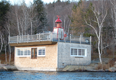
lake: a marina, a lighthouse and a lighted beacon and pontoons, along with boat
garages (another distinct feature of Anglo origin). These are all a part of the
"aquatic" motifs of the landscape.
And so this landscape is the veritable expression of a natural North American landscape
portrait, i.e. where the grand wilderness coexists in complete harmony with the
legendary Canadian cabin.
A Landscape with a Unique History and a Distinct Destiny
The historical aspect of Lac-Tremblant-Nord's heritage value comes from the fact that the region's natural formations are very old indeed, and also, paradoxically, from the traditionally discreet conceal residential developments. Historically speaking, the major transformation that the "original" landscape began to undergo during the 20th century was largely caused by one thing: the onset of vacation cottage development and the developer's limited desire to protect wilderness.
Lac Tremblant owes its name to its Native past. At one time the nomadic Algonquin people crisscrossed this territory, but they eventually withdrew as the lake was privatized in 1915. The Algonquins nevertheless left their mark on the toponymy; for, according to an Amerindian legend, the mountain and the near-by lake are referred to as Tremblant [Trembling] because they would from time to time apparently become the incarnation of Manitou, the Great Spirit and god of nature, who would rumble whenever human beings were so careless as to strike a blow at nature.
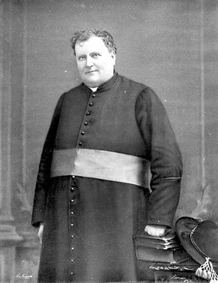
A few French speakers settled in the area sporadically from the 17th century onward, but these communities did not establish permanent communities that would trigger an opening up of the Mont Tremblant wilderness region until the 19th century, although this took eventually place without any settlement on the lakeshore. Father Labelle, the parish priest known as the "King of the North," was instrumental in founding the first parishes, among them Saint-Jovite, in 1879. It included the first village, Tremblant, which was located two kilometres southeast of Lac Tremblant. Labelle helped establish a rural, Catholic French-speaking community whose primary source of economic activity revolved around clearing the woods and practicing subsistence agriculture on the thin soil of a region's known for its rough, rocky terrain and severe winters. Labelle also endeavoured to open up the area to expansion by proposing a rail link to Montreal, and so, the P'tit Train du Nord [Lil' Northern Train) reached Tremblant village in 1904.
As for the English-speaking Protestants, they took advantage of these infrastructures to establish a pulp and paper industry in the region, which was spearheaded by Canadian International Paper (CIP). They were also responsible for the arrival of the first cluster of summer cottages on Lac Tremblant. In fact it was English-language community-with its penchant for building up natural areas-that would eventually instigate the residential trend that developed along the forest's edge near the water. The wooded areas in the regions around the lake began to supply the logging industry that developed upstream, for the most part in the Vallée de la Diable. There was even a log-driving route that cut right across Lac Tremblant from Cachée River in the north to Cachées Falls in the south. This thrust towards industrial development did not alter the lake in any essential way, since most of the cutting took place far enough away, but it did trigger a sort of aesthetic rivalry around the lake as residents sought to impress each other and it also led to the construction of the first summer cottages.
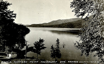
The resident French-speaking population, which traditionally lived in the village back from the lake, provided the first English-speaking cottagers with the services they required. This not only included offering the assistance they needed to reach their lots (by train, cart, taxi or boat) but also supplying the labour for constructing their cottages, as well as for ensuring that they were well stocked and maintained. In addition to being the first to make the lake accessible by opening a hotel on its south shore (operated by Pinoteau and Meilleur), complete with a rowboat so that visitors could ply the lake, the French-speaking community also "served" the Municipality of Lac-Tremblant-Nord during the summer season.
From then on, French and English speakers would join forces in developing this heritage site and, over the years, they began to share not only their experiences, but also a number of common practices. Today the French-speaking community living along the lake is even larger than the English one.
The final decades of the 20th century did however mark a turning point in development of the heritage lakeshore landscape. The La Sérénité and La Tranquillité housing developments, constructed one after the other at the northwest corner of the lake during the 1970s and the early years of the 21st century, have come to define the landscape development model for the area. First of all, an initial access route to the lake was built to service them; then, due to the somewhat monumental scale of the operations, it was deemed necessary to modify the prevailing building standards; and last but not least, the view from the lakefront is at times visibly more ostentatious than what was in the past ever typical of the area. This has set a new trend that encourages ever more residential developments that offer an unobstructed view of the water.
Due to these recent changes, this "wilderness" heritage is increasingly being "devoured" the general public, who access the region both by air and by water. Incursions by airborne tourists and water-skiing enthusiasts have led to the sort of disturbances widely disapproved of by local residents. And so, a wide range of noise pollution, as well as visible disruptions to the landscape have struck a blow to this archetypal landscape that is so emblematic of Quebec natural areas and undermined the considerable efforts that have been made to develop the area in a sustainable manner up until now.
A Unique Identity Construct and Voluntary Conservationist Position
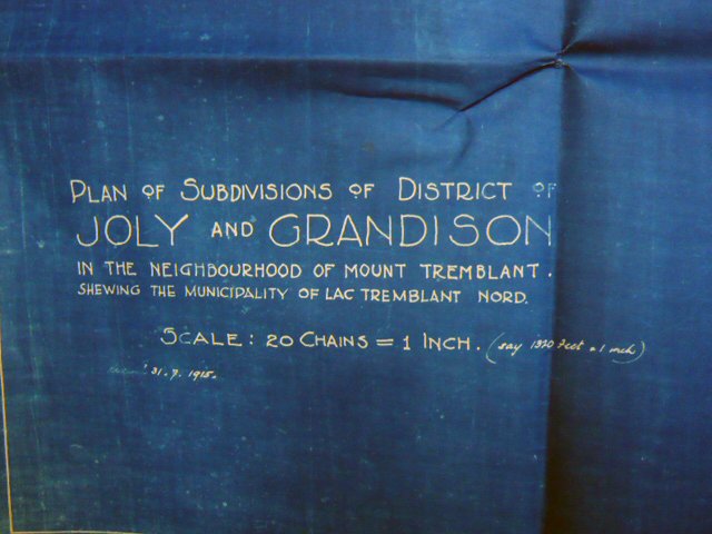
The development of the lake and surrounding forest's heritage is based on the natural features of the landscape that are perceived as desirably "authentic." A long-standing ethos of active protection has had legal consequences: for example, the north-eastern sector of the forest acquired the status of forest reserve in 1895 (even before the creation of Mont Tremblant Provincial Park, in 1981), and following the 1902 fire that ravaged a segment of the wooded shores of the lake, the development of Lac-Tremblant-Nord was legally institutionalized in 1915 by a conservation and responsible-development charter. The predominantly English-speaking and elitist local community (architects, landscape gardeners, teachers, merchants, doctors and lawyers) rallied around this charter, leading to the adoption of a voluntary (heritage) conservationist position.
At this point, the northern part of this naturally enclosed setting was removed from the administrative jurisdiction of the governing body that was previously responsible for it (it was formerly a non-organized territory dependent upon the Labelle taxation district) and given the status of an autonomous municipality whose limits were defined by "the county boundary running between Labelle and Terrebonne that crosses the lake at a distance of approximately two miles from the shore on an angle of approximately 45 degrees."(NOTE 1) From now on, the fate of the northern half of the Lac Tremblant area-which, up until 1915, had remained a non-organized territory-would be very different from the rest of region, particularly in respects to land use management.
The main objective of the 1915 charter was mostly preservationist in nature. In fact it included 13 general-information articles stipulating, most notably, the role of the Municipality and tax accounts; the existence of a lighting committee; a boat committee and a law and order (police) committee. Under the two remaining articles of this initial charter, when outlining regulations and legal orders, the articles tend to address matters of safety (which mostly concerned navigation and on dry land, issues related to isolation from emergency services), environmental protection (waste disposal and species reproduction), as well as the landscape itself, which already took into account the density of any housing development based on a minimum lot size.
A second version of the charter, dating from 1956 (By-law No. 8), entitled Land Use and Construction of Buildings, (NOTE 2) reinforced landscape preservation by regulating new construction with 19 articles that were purposely minimalist and specific: building permits, clauses stipulating distances from the shore, development sizes, and authorised and excluded functions (commercial use was, for example, excluded).
The most recent version of the charter, dating from 1970 (By-law No. 12) and entitled Zoning, Land Use, Construction of Buildings, Sanitation and Anti-pollution By-law, points out in its preamble that the Municipality's rights include regulating and prescribing building construction, building proportions, architectural characteristics and building materials, as well as matters of sanitation. The ambition to protect the heritage value of the area is clearly pointed out in the preamble: "Whereas, in order to preserve the area of Lac-Tremblant-Nord as an area designed for the conservation of nature and the recreation and enjoyment of its property owners and the public at large..." Most notably, this version established the first zoning restrictions, singling out three zones (A, B and C), for different land use, in accordance with the development plan of the regional county municipality that encompasses Lac-Tremblant-Nord.
In 2000, the municipalities of Lac-Tremblant-Nord, Saint-Jovite, Saint-Jovite-Paroisse and Mont-Tremblant-Village were amalgamated. However, this merger was short-lived. For reasons of natural and cultural heritage preservation, Lac-Tremblant-Nord was allowed to de-amalgamate in 2006, in response to a request made in 2004. This tiny municipality had petitioned to recover its autonomy so that it could implement the town-planning initiatives that set it apart from the surrounding municipalities. In fact, Lac-Tremblant-Nord has experienced serious difficulties containing the pressures resulting from the development of the nearby ski resort and Mont Tremblant Provincial Park.
The 1915 charter already provided for the protection of the Lac-Tremblant-Nord landscape and established it as a heritage site. But the resulting identity construct would be nothing without the spirit of aesthetic rivalry that, in and of itself, would inspire feelings of attachment in the residents of Lac-Tremblant-Nord, which would then in turn give birth to a desire to ensure the protection of the entire locality.
A Region Inspires Artistic Emulation
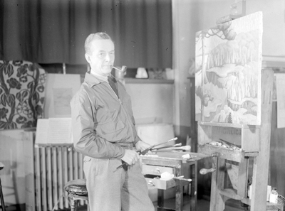
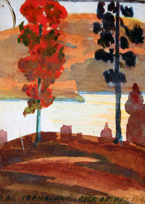
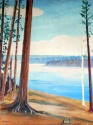
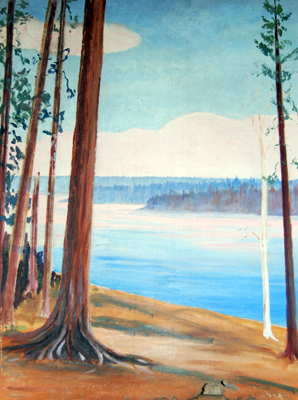
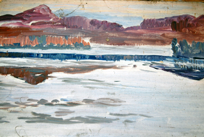
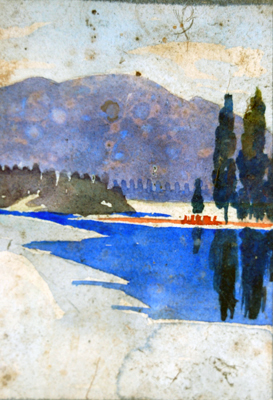
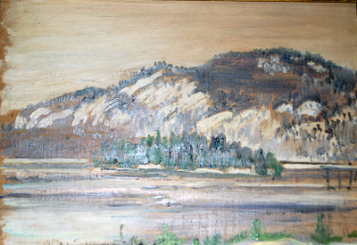
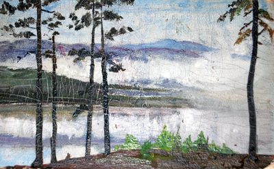
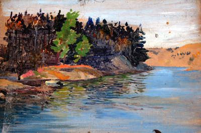
From the earliest days of resort and cottage development, architects, landscape architects, painters and writers marked in the community in such a way that it had an influence on the very formulation of the 1915 charter and prompted the sector's heritage development. Underlying the narrative that they translated into images is transcendentalism, the philosophy of American writer Henry David Thoreau (1817-1862), inspired by his experiences on the shores of Walden Pond. Thoreau wrote a book entitled Walden; or, Life in the Woods, published in 1854, in which he takes a stand against the industrial revolution and the consumerist society that it created. In particular, Rickson A. Outhet (landscape architect) and Maurice Cullen and Edwin Holgate (painters associated with the Group of Seven) were very much in tune with the genius loci [lat. local divinity - today refers to the prevailing mood or atmosphere that animates a locality] of Lac-Tremblant-Nord and helped confer an artistic dimension upon it.
At the same time, the evocative power of the landscape, a reflection of Canadian nature, inspired the writer Marie Le Franc, who drew upon the unique qualities of the region for certain scenes of her novel Hélier, Fils des Bois (1937), set at the beginning of the 20th century. When it comes to creating images of the region, the torch has now been passed most notably to the painter Michel Normandeau and to other artists such as Sylvie Legaule.
A Threatened Heritage
The Lac-Tremblant-Nord landscape is highly emblematic and has attracted the attention of a substantial community of outdoor aficionados since the beginning of the 20th century. An entirely voluntary conservationist position, which was founded on the powerful emotional attachment that the region has evoked for many, has enabled it to become established as a natural and cultural heritage site. It is the very notion of the "authentic" wilderness in harmony with the legendary scenic Canadian cabin that inspires these strong feelings of attachment. Nevertheless, this highly coveted area continues to be subject to outside pressures generated by the allure of the ski resort and Mont Tremblant Provincial Park. Even among residents of Lac-Tremblant-Nord, certain new tendencies are threatening the area's heritage character, which has been preserved up until now. Could this natural heritage now become a victim to the success of its own particular brand of conservationism?
Fabienne Joliet
Lecturer,
INH Paysage [Landscape Architecture], Angers, France
Scientific delegation to the École
d'architecture de Paysage, Université de Montréal, 2007-2008
Claire Gourbilière
Fifth-year student at the École Nationale d'Ingénieurs de l'Horticulture et du Paysage (France); Territorial Engineering Major
NOTES
Note 1: Lac-Tremblant-Nord Charter of 1915, General Information, § 2. [Original citation translated into English for this text].
Note 2: Until the Charte de la Langue Française [French Language Charter] became law in Quebec in 1977, municipal texts were all in English.
BIBLIOGRAPHY
Beaudet, G., « Un bref regard sur l'architecture de la villégiature et du tourisme », Téoros, vol 15, n° 1, 1996, p. 39-42.
Brasset, Y., Lac-Tremblant-Nord : une municipalité sans résident, sans route, ni électricité. (réf complète ?), 1997.
De Blois Martin, Charles, « L'expérience touristique, retrouver les liens échappés », Actes du colloque de l'Université rurale québécoise au Bas-Saint-Laurent, 4-8 octobre 1999. [En ligne]
Fournier, M., Histoire du Parc du Mont Tremblant, Québec, Ministère du Loisir, 1981, 65 p.
Joliet, F., et T. Martin, « Les représentations du paysage et l'attractivité touristique, le cas Tremblant dans les Laurentides », Téoros, vol 26, n° 2, 2007, p. 52-58.
Potvin, M., Mont-Tremblant, au cœur des Laurentides, Outremont, Le Trécarré, 2003.
Verdon, M., Anthropologie de la colonisation au Québec. Le dilemme d'un village du Lac-Saint-Jean, Montréal, Les Presses de l'Université de Montréal, 1973, 283 p.
Additional DocumentsSome documents require an additional plugin to be consulted
Images
-
 Bleu - Municipalité L
TN -
 Bleu - Municipalité L
TN -
 Photographie d'un tab
leau de R. Outh... -
 Photographie d'un tab
leau de R. Outh...

-
 Photographie d'un tab
leau de R. Outh... -
 Photographie d'un tab
leau de R. Outh... -
 Photographie d'un tab
leau de R. Outh... -
 Photographie d'un tab
leau de R. Outh...

Vidéo
Document sonore
Documents PDF
-
 Extrait du roman de Marie Le Franc, Hélier, fils des bois
-
Extraits de la charte de la municipalité de Lac-Tremblant-Nord de 1915
-
Extraits du journal de R. Outhet, architecte-paysagiste appartenant au groupe des initiateurs de la charte de 1915